Resource icon

Lndromat v0.99 Update 1.0.0

I'm guessing the lack of a Download button on this page means this project has been taken down? That's unsettling; I've been told this is the best map editor out there for BnW .lnd files...
 
Hey Shrooblord

Matt was able to find a copy that he had download before Kayssplace went down. We've added it back in.
 
Awesome! Thanks!!

Unfortunately, I don't seem to be able to open my .raw files to start the map making process.

I'm using GIMP to export a heightmap as raw image data (file extension .data), then rename the extension to .raw manually. Then, when I try to open it in lndromat, the program just closes -- a crash?

I can't seem to find online how to export anything as a .RAW file; Minas's tutorial here seems to suggest to just "save the file as a .raw image", but all the sources online that I could find say that can't be done, and that .RAW images are only supposed to be imported, not exported.

Anyone know of a good .LND editing / creation tool that can import 2D heightmaps of other filetypes? PNG for example? I love the idea of lndromat, and using the dummy files contained in the 0.96 release I can see it works, just not for my own files.

Any other suggestions into how to get into map editing / creation for BnW are welcome. I like the flow of creating a heightmap first, so if that's still possible in another way, that'd please me.

Thanks


====

EDIT:
It looks like Nospher had the same problem as I did, and that they posted a work-around that worked for me, too. Instead of creating a heightmap from scratch, I import and edit-in-place the sample one provided with the lndromat installation. Then I save it as .DATA and rename to .RAW, as described above. This now imports into lndromat!

However, it still is very error-prone: some situations seem to bug out and crash the program, and I haven't yet figured out why.

But for now, I can create and import heightmaps. Awesome! Off to landscape painting...!
 
Alright! After extensive testing and a bit of headache, I have figured out the source of the crashes.

For me, at least, the following does not produce a crash:
1. Create a 512x512 image in GIMP.
2. Make sure only a continuous square area of 255x255 of that image, or less, is non-black i.e. any value higher than #000000.
3. Any pixel within this square can be any grayscale value between #000000 and #ffffff (although #ffffff will produce extreme mountains for the game).
4. Export as raw data in GIMP, using Planar settings --> it gets the .data extension.
5. Rename the file exension to .raw manually.
6. Import into lndromat.
7. Use the "dummy" .DDS file that came with the 0.96 release of lndromat but wasn't included in the current release.
8. Use the texture files from another land, for example Land1.lnd from the basegame -- or use your own texture set of course -- see instructions in the lndromat readme, in release 0.96.
9. Save as any filename.lnd.
10. Open in BW Surveyor --> confirm that the land looks like the heightmap as expected, and doesn't have any weird, jagged aliasing artefacts.
11. The land appears to be rotated 180 degrees from what you exported your image as, however. Keep that in mind if that's any sort of important to you. However, in-game, you'll be rotating around a lot anyway, so I'm not sure it matters much really unless you're very particular about on which part of your map the sun rises and sets. If so, experiment away and tell me what you find...!


Any other image size, or exceeding this "256x256 square within the 512x512 image" rule seems to crash lndromat on import. Staying withing those bounds, within the larger image, however, is fine! Any other image sizes produces either very weird resulting .LND files when inspected in BW Surveyor (think horizontally tiled versions of your heightmap, or extremely jagged toothbrush-like-looking landscapes), or simply crashes lndromat, making you unable to even produce the .LND file in the first place.

But keep to these steps, and you should be good to go!  :yourock:

My tip: create a layer that's 256x256 inside your 512x512 project, and make a 512x512 layer that's your bottom layer, filled in completely black. This is your "background layer". The 256x256 layer can be transparent on the edges, so you only have to "paint onto the black background", and when you export as raw data, it will flatten the image correctly without trouble. This is what I do, so that I know where my 256x256 bounds are (since they're where the layer ends).

However. If the "import textures from land file?" step is supposed to allow the program to generate textures that make sense, i.e. sand on beach areas, snow in the hills, rock/grass/dry grass in places -- then that's not what happens. Also, the Dummy.DDS file shows its ugly red-and-white stripes when you play the map in-game until you've scrolled over the area with your camera at least once, so it's probably worthwhile to find out where to get some proper low-res .DDS texture somewhere in the game's files (if you wanna use the official textures).

For the which-texture-where problem I assume I still need to define "countries" somehow, which is something I'm sure I've read about somewhere, but am not sure yet how to put into my maps.
 
Just here again after some years to provide an update to my earlier struggles from back then; I actually ran into many of the same issues as before (I'm doomed to repeat myself over and over again, huh), but was able to resolve them too. I've been happily mapmaking for the past few days with no issues.

Here's a quick and dirty overview:
- Download LndroMat
- Download BWSurveyor
- There's a resource out there called the Landscape Creation Kit v1.2 which I highly recommend; it has some templates here and there and useful docs. I did end up amending the docs myself on my end with my findings while mapmaking but I digress.
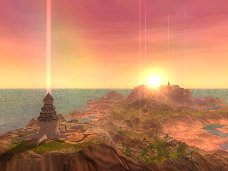
- I personally really enjoy using the openblack project as a map viewer. Debug > Show villager names. And Debug > Game Overview to read out coords in-world and add to the Script file!
- Create a heightmap image in GIMP as instructed; a 512x512 texture of black with a 256x256 internal square within which you confine your heightmap (0-255 greyscale values). Any non-black pixel outside of theis 256x256 internal square will crash LndroMat
- I suggest creating a clipping layer in GIMP of the appropriate size for all your layers of landscape design. This will ensure that no pixels cross the boundary.
- Export as RAW. I needed to install RawTherapee in order to export RAW files.
- Make sure to use Planar RRR,GGG,BBB mapping!! Otherwise... you guessed it: crash
- Open your .raw file with LandroMat. Use the DUMMY.dds file and say you want to import landscapes, e.g. from Land5. Note: this land you use as a template cannot be the same land you end up saving over, or the save won't actually go through and will silently fail.
- Save!
- Open BWSurveyor, e.g. RC2. Open your LND. Go into Modify > Edit mode.
- You can click any of the Blocks and change the Countries (textures).
- I cycle through the available textures, e.g. selecting the one with sandy beaches and snowy tops, and then hit Apply to whole Landscape. You could paint each Block individually of course, but I didn't find the tooling very intuitive, and this texture suits my needs.
- Save. BWSurveyor RC2 will actually fix some glitches with landscapes, get rid of the ugly white-and-red DUMMY.dds textures, and leave your LND file in a useable state!
- Copy the LND file to the BnW install directory under ./Data/Landscapes.
- Create a Script file and put it in ./Scripts/Playgrounds.
- You're done! Time to start iterating and playtesting :D
 
Back
Top